


OS Maps
Walk, Hike, Run, Bike
Περιγραφή του OS Maps: Walk, Hike, Run, Bike
Με τους Χάρτες OS ως υπαίθριο οδηγό σας, οργανώστε περιπέτειες με αυτοπεποίθηση και ανακαλύψτε εκπληκτικές διαδρομές μονοπατιών σε όλο το Ηνωμένο Βασίλειο και πέρα από αυτό. Βγείτε έξω με τους Χάρτες OS και αποκτήστε περισσότερα. Περισσότερη ελευθερία εξερεύνησης, περισσότερες περιπέτειες και περισσότερη σύνδεση. Είτε θέλετε έναν προγραμματιστή διαδρομών τρεξίματος για να διατηρήσετε τα πράγματα γραφικά, έναν δημιουργό ποδηλατικής διαδρομής για να παραμείνετε ενεργοί ή ένα περιοδικό γυμναστικής για να σας εμπνεύσει, οι Χάρτες OS είναι ο οδηγός σας στην υπέροχη ύπαιθρο και την επίσημη εφαρμογή της Ordnance Survey.
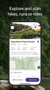
ΕΞΕΡΕΥΝΗΣΤΕ ΚΑΙ ΣΧΕΔΙΑΣΤΕ ΠΕΡΙΠΤΩΣΕΙΣ, ΤΡΕΞΕΙΣ Ή ΒΟΛΤΑ
Είτε θέλετε να περπατήσετε, να πεζοπορήσετε, να τρέξετε ή να οδηγήσετε, οι Χάρτες OS σάς βοηθούν να δημιουργήσετε περιπέτειες σε εξωτερικούς χώρους με αξιόπιστα εργαλεία χαρτογράφησης και πλοήγησης από τους ειδικούς της Ordnance Survey, της εθνικής υπηρεσίας χαρτογράφησης της Βρετανίας. Σχεδιάστε τις εξερευνήσεις των μονοπατιών σας με λεπτομερείς χάρτες, επιμελήστε τις διαδρομές σας χρησιμοποιώντας το πρόγραμμα σχεδιασμού διαδρομής τρεξίματος και καταγράψτε τις βόλτες σας με τον δημιουργό και τον ιχνηλάτη ποδηλατικής διαδρομής. Όποια και αν είναι η δραστηριότητά σας που προτιμάτε, οι Χάρτες λειτουργικού συστήματος είναι το ολοκληρωμένο εργαλείο πλοήγησης, το πρόγραμμα παρακολούθησης φυσικής κατάστασης και ο σύντροφός σας για την ψυχική υγεία.
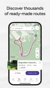
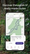
ΑΝΑΚΑΛΥΨΤΕ ΧΙΛΙΑΔΕΣ ΕΤΟΙΜΕΣ ΔΙΑΔΡΟΜΕΣ
Βγείτε έξω με επιλεγμένες διαδρομές από ειδικούς σε εξωτερικούς χώρους και οργανισμούς όπως το Trail, το Country Walking, το Mountain Bike UK, το BBC Countryfile και άλλα.
ICONIC OS MAPPING
Εγγραφείτε για να ξεκλειδώσετε τη λεπτομέρεια και την ακρίβεια των χαρτών αναψυχής του λειτουργικού συστήματος, συμπεριλαμβανομένων των OS Explorer 1:25.000 & OS Landranger 1:50.000. Τώρα με την παγκόσμια χαρτογράφηση και τοπογραφική χαρτογράφηση για τις ΗΠΑ, την Αυστραλία και τη Νέα Ζηλανδία για να σας κρατήσουν να εξερευνάτε σε όλο τον κόσμο.
ΔΗΜΙΟΥΡΓΗΣΤΕ ΤΙΣ ΔΙΚΕΣ ΣΑΣ ΠΕΡΙΠΕΤΕΙΕΣ
Χαράξτε το δικό σας μονοπάτι με γρήγορη και εύκολη σχεδίαση διαδρομής snap-to-path και τα καλύτερα εργαλεία σχεδιασμού διαδρομής και πλοήγησης στην κατηγορία. Είτε πρόκειται για περιπάτους σε μονοπάτια ψυχικής υγείας είτε για καθημερινές δραστηριότητες γυμναστικής, θα φροντίζετε την ευεξία σας και θα παραμένετε στην κορυφή των στόχων φυσικής κατάστασης με τους Χάρτες OS ως τον αξιόπιστο προγραμματιστή διαδρομής τρεξίματος, τον δημιουργό ποδηλατικής διαδρομής και τον οδηγό πεζοπορίας. Σχεδιάστε διαδρομές, στη συνέχεια αποθηκεύστε και μοιραστείτε με τους φίλους σας για να σχεδιάσετε την επόμενη επική μέρα σε εξωτερικούς χώρους.
ΟΧΙ ΣΗΜΑ; ΚΑΝΕΝΑ ΠΡΟΒΛΗΜΑ
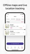
Κατεβάστε χάρτες και διαδρομές στο τηλέφωνό σας για προβολή εκτός σύνδεσης, ώστε να είναι έτοιμοι για την απομακρυσμένη πεζοπορία και την ανοιξιάτικη ποδηλασία στην πόλη. όποτε, οπουδήποτε. Δείτε οποιοδήποτε μέρος του GB χωρίς σήμα και εξάγετε τις διαδρομές σας στη συσκευή σας GPS.
ΑΠΕΡΙΟΡΙΣΤΗ ΕΚΤΥΠΩΣΗ
Εκτυπώστε αντίγραφα όλων των διαδρομών και των χαρτών σας για να έχετε μαζί σας, ώστε να έχετε πάντα στη διάθεσή σας ένα αντίγραφο ασφαλείας.
ΧΡΗΣΗ ΣΕ ΚΑΘΕ ΣΥΣΚΕΥΗ
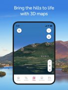
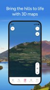
Συγχρονίστε τις δραστηριότητές σας σε όλες τις συσκευές, σε επιτραπέζιους υπολογιστές και κινητά. Σε επιτραπέζιους υπολογιστές, οι premium χρήστες μπορούν να χρησιμοποιήσουν το 3D Aerial Layer και τις διαδρομές που διανύουμε για να δουν το τοπίο, το έδαφος και να εξερευνήσουν εκπληκτικά 3D.
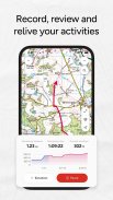
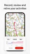
ΔΡΑΣΤΗΡΙΟΤΗΤΕΣ TRACK & RECORD
Χρησιμοποιήστε τη λειτουργία καταγραφής δραστηριότητας ως ημερολόγιο γυμναστικής σε εξωτερικό χώρο, ημερολόγιο περιπάτου ευεξίας και παρακολούθηση ποδηλάτου για να παρακολουθείτε όλους τους περιπάτους ψυχικής υγείας, τα μονοπάτια και τις ποδηλατικές εκδρομές σας. Το OS Maps είναι το πρόγραμμα παρακολούθησης φυσικής κατάστασης σε εξωτερικούς χώρους για να αποθηκεύετε τη δραστηριότητά σας, να μοιράζεστε και να ακολουθείτε μαζί με φίλους και να χρησιμοποιείτε ως προσωπικό ημερολόγιο υγείας και φυσικής κατάστασης.
ΣΥΣΤΗΝΕΤΑΙ ΑΠΟ ΤΟΥΣ ΕΙΔΙΚΟΥΣ
Η Ordnance Survey είναι περήφανη που συνεργάζεται με το Mountain Rescue England & Wales, με τους Χάρτες OS ως την προτεινόμενη εφαρμογή τους για να σας βοηθήσουν να παρακολουθείτε τους στόχους σας για τη φυσική κατάσταση και την ευεξία και να είστε ασφαλείς όταν βγαίνετε έξω.
Βραβευμένη ΤΕΧΝΟΛΟΓΙΑ ΧΑΡΤΗ
Το OS Maps έχει ψηφιστεί ως η εξαιρετική εφαρμογή της χρονιάς για εξωτερικούς χώρους για 7 συνεχόμενα χρόνια! Yahoo Sports Technology Awards Best App, Outdoor Industry Awards Digital Product of the Year & Singletrack Best Online Service.
ΧΡΗΣΙΜΕΣ ΠΛΗΡΟΦΟΡΙΕΣ
Η διάρκεια ζωής της μπαταρίας μπορεί να μειωθεί δραματικά χρησιμοποιώντας συνεχώς το GPS.
Δημοσιεύουμε ενημερώσεις σε όλες τις εφαρμογές μας καθώς τις βελτιώνουμε, καθιστώντας τις ακόμα πιο σταθερές και προσθέτοντας επιπλέον λειτουργίες. Η τοπογραφική χαρτογράφηση είναι διαθέσιμη για το Ηνωμένο Βασίλειο (συμπεριλαμβανομένης της Βόρειας Ιρλανδίας), τις ΗΠΑ, την Αυστραλία και τη Νέα Ζηλανδία. Τα σχόλιά σας και τα σχόλιά σας σχετικά με αυτές τις εφαρμογές είναι πολύ σημαντικά για εμάς. Αφήστε μια κριτική ή χρησιμοποιήστε το os.uk/contact για να έρθετε σε επαφή.
Ανακαλύψτε διαδρομές πεζοπορίας, διαδρομές πεζοπορίας, μονοπάτια ποδηλασίας και πολλά άλλα με την εφαρμογή που σας επιτρέπει να εξερευνήσετε τη χαρά της υπαίθρου της Μεγάλης Βρετανίας. Είτε θέλετε να κάνετε πεζοπορία, ποδήλατο, τρέξιμο, πεζοπορία ή περπάτημα - ανακαλύψτε χιλιάδες συναρπαστικούς χάρτες και διαδρομές σήμερα!
Όροι & Προϋποθέσεις στο os.uk/termsosmaps
OS Maps: Walk, Hike, Run, Bike - Έκδοση 5.4.1.1377
(03-04-2025)OS Maps: Walk, Hike, Run, Bike - Πληροφορίες APK
Έκδοση APK: 5.4.1.1377Πακέτο: uk.co.ordnancesurvey.osmapsΤελευταία έκδοση του OS Maps: Walk, Hike, Run, Bike
Άλλες εκδόσεις


Εφαρμογές στην ίδια κατηγορία

Μπορεί επίσης να σου αρέσουν...


